An Appalachian Trail Thru-Hike: Part 31 - Entering Maine and Hiking the Mahoosucs
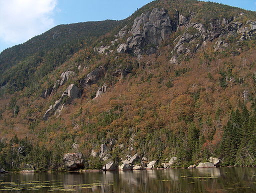
It looked inviting, like a trading post in the midst of the wilderness.
Wildcat Mountain and a Detour to Gorham, NH
Across the road from Pinkham Notch Lodge the Appalachian Trail plunges into the woods and very shortly begins the steep ascent of Wildcat Mountain. We had just waved goodbye to our friends as they drove back to New York after spending a weekend with us hiking the AT over the Presidential Range in New Hampshire’s White Mountains. After their car disappeared into the distance we turned and followed the trail up the mountain.
There is a ski resort on Wildcat Mountain and before long we found ourselves passing the large cylindrical supports of a chair lift as we climbed. After a strenuous hike we found ourselves at the top of the mountain, pleasantly surprised to find an open snack bar. We shrugged out of our packs and walked inside. There were windows that looked out on the view of Pinkham Notch and Mt. Washington. We ordered some snacks and sat in front of the windows for a long time, taking in the view. We ended up spending a large portion of the day on top of Wildcat Mountain. It was well into the afternoon before we shouldered our packs and continued hiking northward. In the end, we only hiked 6 miles for the day. We stopped for the night when we reached Carter Notch Hut. Carter Notch Hut is the last of the AMC Huts that a northbound AT hiker passes. We had no reservations at the hut, but there were tent sites that surrounded it. From our tent site we could look over and see lights glowing in the windows. We knew the guests were enjoying a hearty dinner while we cooked our camp food over Dave's Coleman Peak I. It looked inviting, like a trading post in the midst of the wilderness.
We got off to a late start the next morning and we hiked slowly throughout the day. Part way through the day, we came across a side trail called the Stoney BrookTrail that led into Gorham, New Hampshire. We took it, thinking we might be able to find a good place to eat there. It took us until evening to arrive in Gorham, but we were rewarded by finding a great pizza place called "The Cave". After we ate it was almost dark. We thought about getting a place to stay, but it was a nice night and our money was dwindling, so instead we struck out east along route 2, hiking toward the point where the AT intersects. We hiked about 2 1/2 miles before we spotted a nice-looking spot to camp screened from the road by a thick patch of trees. There we passed the night before we woke up the next morning and finished the road walk to the AT intersection along route 2.
We met the well-known thru-hiker Ed Garvey in northern New Hampshire
If you want to read this series from the beginning, click the link below:
- An Appalachian Trail Thru-hike: Part 1 - Deciding to...
Two teenagers hike the Appalachian Trail from end to end in 1982. This episode describes how they decided to hike the trail and their preparation for the trip.
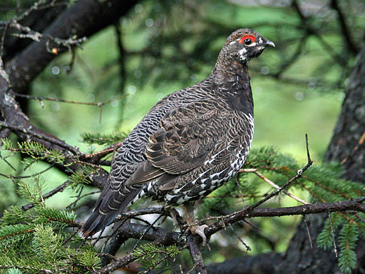
"... I'm going to try to get one with my stick so we can have some fresh meat for dinner!"
An Eventful Day
A little while after we got back on the trail we crossed over a dam on the Androscoggin River which forms the Androscoggin River Reservoir. Beyond that we started climbing. We were crossing an open rocky area on a mountainside when we looked up to see a group of three people heading southbound toward us. They were led by a lean older man with snow white hair. He was wearing a blue hiking outfit that looked very familiar to me. We stopped in the middle of the trail and exchanged pleasantries. The man with the snow white hair did most of the talking. He asked us if we were thru hikers, when we had started, and a few other things about our trip. We talked for less than 5 minutes before we wished each other well and continued on our separate ways. A few seconds later Dave looked over at me.
"Was that Ed Garvey?" he asked.
"I think so," I replied.
We had both realized it at about the same time. I had recognize the blue outfit and the snow white hair from the cover photo on my book "Appalachian Hiker II" which my parents had given me the previous Christmas to help me get ready for my hike. Ed Garvey was a famous Appalachian Trail hiker whose first thru hike was in 1971. He wrote a book called “Appalachian Hiker, Adventure of a Lifetime”. In 1978 he wrote another book called “Appalachian Hiker II”. The trail guide I started the trip with was a supplement that came with the book. Since then Dave and I had replaced it with more updated and more detailed guides, but the initial guide helped us get through the first 100 miles or so of our trip. Now we were pretty sure we had met him in person along the trail in northern New Hampshire.
It turned out that our meeting with Ed Garvey was just the first surprise in a day full of surprises and interesting experiences. To begin, it was a beautiful sunny day and the hiking was through beautiful country. We were now frequently hiking through patches of thick conifer forest. Whenever we passed through the conifer forest, we encountered a different type of bird than we had seen before. From descriptions we had heard from other hikers and books we had read, we surmised that these birds were spruce grouses. They reminded us of the partridges we had in our woods back home. The difference was that the spruce grouse was a little bigger and seemed to be dumber. We would be hiking along, and suddenly one would flush from beneath a thick patch of spruce or fir. Back home, the partridges used to do that as well, but the partridges flushed when we were 15 to 20 feet away or more. The spruce grouses waited until we were right on top of them. We would get about 3 feet away and be surprised by a sudden flurry of wings. The bird would fly out from their hiding places a couple feet in front of us. The abrupt flushing always made us jump. It was as if by hiking along the trail, we were cranking a nature – made Jack–in–the–box, and suddenly – Pop! The grouse would be flapping a foot or two in front of our faces, and we would be jumping a couple feet into the air. After this happened to us a half dozen times or so, Dave stopped and turned to me.
"If these dumb birds are going to let us get so close before they flush, I'm going to try to get one with my stick so we can have some fresh meat for dinner!"
I shrugged, "All right," I said.
I didn't think it was too likely because it was going to be hard to react fast enough to get one and they usually flushed in the thickest portions of the woods where there wasn't a lot of room for us to swing our hiking sticks due to trunks of the small spruce and fir trees crowding the trail on either side. Still, as we hiked on from that point we tried to whack them whenever they flushed in front of us. My attempts consisted of some halfhearted swings, and I didn't come close. Even Dave, who was a hunter back home, didn't have any luck as the day wore on.
At lunchtime we stopped at Genetian Pond lean-to which was a beautiful shelter built on a promontory above the pond. The view was a wonderful overlook of mountains in the distance, and the shelter was clean and spacious. We enjoyed our lunch in the sunshine, then shouldered our packs again and moved out. We could see from our maps and terrain profiles that there were some steep climbs ahead of us.
We were in the middle of the Mahoosuc Range that straddles the border of New Hampshire and Maine. Months earlier, just a few days into our trip, Dave and I had encountered a guy who had hiked the entire trail two years earlier. We asked him what the hardest section of the AT was and he had told us the Mahoosucs. Already our day had included some steep climbs. The ones ahead appeared to be even steeper based on the closeness of the brown topographic lines on our maps (they were so close they created a solid band of brown). That was supported by the terrain profiles on the bottom of the maps which showed some spots where the trail went straight up. We were pumped up. The trail and all the surroundings felt remote and gave us a sense of isolation. We could already notice a big difference in the number of people we were seeing on the trail. Throughout our thru hike we had usually run into several people per day and at times several an hour. Now we were only seeing occasional people. The terrain was rugged and the forest was taking on the characteristics of how we pictured the north woods - with spruce, fir, pine, lakes, and steep rough mountains. The whole atmosphere was appealing to our sense of adventure – the ideal of the mountain man – to be a part of a primitive American wilderness. It was something we felt, not something we could describe, but it was definitely there. As the hours of the day had passed, that feeling had seeped into our bones and now we wanted to plunge back into it and just enjoy the experience of being a part of the wild world around us. It was just as we were embracing the wilderness and focusing on the mountains, rocks, and trees, that an unexpected twist in our day made us forget all that for a while.
After we left Genetian Pond lean-to, Dave got out ahead of me a little ways. I was hiking by myself along a straight section of trail where I could see good distance ahead of me. Suddenly I saw another hiker coming toward me. This person looked to be a guy walking with his shirt off. As we drew closer to each other I realized that it wasn't a guy after all. The person hiking toward me was a young lady hiking topless. She was hiking fast and carrying a large backpack. Instantly my 18-year-old brain started trying to think of some witty or cool remark to make. I suppose I wanted to see if I could get her to stop and talk to me for a while, but all I could manage when we passed each other on the trail was to say "Hi."
"Hi," she answered as she breezed on by.
I kept on hiking, and it was only a few short moments later that I sighted Dave standing in the middle of the trail waiting for me to catch up. Doubtless he wanted to see my reaction, and the look on my face must've told him all he needed to know, because as soon as he saw me he doubled over with laughter.
We took a short water break at that point where we each recounted our surprise at encountering a topless lady hiker. For the moment, our union with the wild world took a backseat to our hormones. After a short time though, there was nothing else to do but to shrug back into our packs and head on down the trail, wondering if she had any friends coming along behind her. Of course that was not the case, and later in the afternoon we reached a landmark that reminded us of why we were really out there hiking the trail.
At 4:30 in the afternoon we came to a sign post that marked the New Hampshire – Maine border. We stepped past the sign into the state of Maine and felt a surge of psychic energy. So much of hiking the AT hinges on mental aspects of the trip. Reaching landmarks provides a big boost to thru hikers. All the day-to-day hiking – the slow progression along the trail – makes the trip seemed to drag sometimes. When a major landmark is reached, there is a combination of pride, relief, excitement, and happiness that floods the spirit. A hiker’s feet then seem to float along the trail and every step feels like it covers miles. Crossing into Maine reminded me of some wood cut illustrations that were in an old book I had when I was a kid. It was about the American folk hero, Paul Bunyan. The woodcuts showed the giant, bearded logger striding through the north woods, his footsteps forming lakes and the axe dragging behind him forming rivers and streams.
A little ways further, we stopped at Carl's Col lean-to where we ate dinner. Examining our maps, we could see that the next lean-to, Full Goose Shelter, was within striking distance before dark, but there were some steep climbs between us and the shelter. We were in a great hiking rhythm, the best we had felt in a long time, so we didn't give it much thought. We quickly packed up from dinner, swung the packs back onto our backs, and started tramping along the trail again. There were two steep climbs – as steep as any mountain either of us had ever climbed. The slopes were so steep that we had to reach way above our heads to plant our walking sticks onto the ground in front of us as we hiked. We planted our sticks with one hand and grabbed onto handholds with our free hands. Climbing the Mahoosucs was like climbing a ladder. We carefully planted our feet into footholds such as flat tops of rocks or cracks in rocks, or exposed roots. On either side of the trail grew stunted fir and spruce trees clinging to the slope. They offered holds for our free hands. A few times we stopped and turned to look behind us. All the stunted trees were at eye level or lower. We paused clinging to the tree branches on either side of us, our hiking sticks for a moment dangling from our wrists by the string loops that passed through the handles. The evening air was clear and warm. The views were magnificent – conifer covered mountains stretching into the distance with a few lakes and ponds sparkling from the light of the setting sun.
The Mahoosucs were steep, but not very tall. We were to the top quickly and then we had to scramble down the other side. There were two peaks we had to climb that way – they were both part of Goose Eye Mountain, and when we were finished we came to Full Goose Shelter. There we came across our last surprise of the day. At Full Goose Shelter we found our old friend Clayton who was hiking with his brother. There were also two other guys who we had met at Kitchen Brook Lean-to. We hadn't seen Clayton since Connecticut at the end of June when he gave us each a tuna sandwich at Mohawk Shelter. There was a lot of catching up to do – each of us telling the other what had transpired for us since we had last met. One thing both Dave and I noticed was that Clayton was looking much thinner than when we had last seen him. He had been a husky guy when we first met him, but since then the rigors of the trail had caused him to drop some significant weight. The conversation lasted until darkness fell. Then we all obeyed the natural cycle of the sun, and we slid into our sleeping bags to recuperate from our long and eventful day.
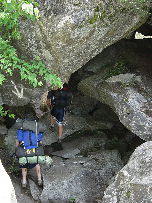
“The Toughest Mile on the AT”
Morning brought overcast skies. Once again we were charged up, because according to many of the guides, articles, and talk on the trail, we were about to encounter Mahoosuc Notch, the "toughest mile on the Appalachian Trail". Mahoosuc Notch was famously described as a narrow passage that was strewn with boulders where AT hikers had to climb, crawl, squeeze, and wriggle their way through to get to the other side. The obstacle course was a mile long. For northbound hikers it was the precursor to climbing the last and tallest mountain in the Mahoosuc Range – Old Speck Mountain. Dave and I had heard about this section of the trail since before we had even left on the trip. We had heard and read so much about it, that we were anticipating a complex of caves and nearly impassable rock walls that we practically needed ropes to navigate through. Much of the writing about Mahoosuc Notch talked about how hikers had to remove their packs and push them through narrow openings in front of them then follow through. We remembered the Lemons Squeezer in Harriman State Park in New York State, where we really did have to take off our packs to squeeze through a split rock. Dave and I expected that there was going to be about a mile of that.
As it turned out, Dave and I being 18 years old and in the best shape of our lives, were so skinny and agile by that time, that the obstacles in Mahoosuc Notch didn't turn out to be that difficult for us. We never had to remove our packs and the boulders that we climbed over or squeezed between weren't so impassable. We were through the Notch before we knew it, and as the trail opened up and the boulders were left behind, Dave and I looked at each other.
"That's it?!" we asked each other, "That was the toughest mile on the AT?!"
"Yesterday evening was a lot tougher than that," we exclaimed.
"Cheoah Bald was harder too," we added, remembering the steep mountain just outside Wesser, North Carolina.
It was a perfect example of too much hype spoiling what could have been a cool surprise if we hadn't heard anything ahead of time. In retrospect, Mahoosuc Notch was pretty interesting. It was a narrow passage between two steep mountainsides filled with boulders, exactly the way it had been described to us. The disappointment originated from it being oversold as a nearly impassable obstacle course. As a result we were disappointed by unrealistic expectations. In reality, it was a very interesting section of trail and if we had taken the moment to appreciate it rather than to judge it against a bunch of hype, we probably would have been fascinated.
Our disappointment was compounded by the fact that almost as soon as we exited Mahoosuc Notch, it began to rain. The rain was hard and we decided to hole up and wait it out. We found what appeared to be a flat area to set up our tent. We crawled in and rolled out the sleeping bags to rest until the rain stopped, or at least until it slowed down. Unfortunately, the rain kept falling steady all day and into the night. It was a long wait. and sometime during the middle of the night we found out that the flat spot where we pitched the tent wasn't really as flat as we thought. It turned out that we had set up the tent in the middle of a very slight depression. Over time the steady rain slowly settled into the depression and the ground became saturated. During the night one of us noticed that the floor the tent was wet. When we turned on a flashlight we could see little puddles of water in between our sleeping bags. Further investigation revealed that the undersides of our sleeping bags were wet. It wasn't a complete soaking yet, and we could hear that the rain was tapering off, so we decided to ignore it, go back to sleep, and deal with it in the morning. Luckily for us, the rain did end up stopping during the night.
Morning brought overcast skies and a dripping forest, but the rain was over. We got up and assessed our situation. The sleeping bags were wet, but not completely soaked through, and of course the floor of the tent was completely wet. The contents of our packs were dry as were the insides of our boots. We didn't want to pack up wet sleeping bags for fear of mildew, so we decided to build a fire for drying things out. After we ate breakfast we scrounged around for any kind of dry wood that we could find. After all the rain, everything on the ground was wet. The best luck we had was to break off small twigs that stuck out from the trunks of spruce and fir trees where the thickly needled branches protected them from raindrops. To get a decent flame going, we cut some green fir and hemlock bows thick with needles. The sap in the needles and the branches provided a flare of flame when we first lit them. The flame quickly died out, but it was enough to ignite the dry twigs. After that, it was a matter of slowly feeding in larger branches. The flames would dry them out enough for them to burn and then we could set a couple larger ones on after that. We had to be careful that we didn't try to pile on too many wet branches at once, or the flame would dissipate from too much moisture.
After about a half hour of careful tending, the fire built up some coals to sustain heat and we were able to add enough wood on to have a usable fire. Soon we were squatting over the flames carefully holding the wet sections of our sleeping bags over the fire. Steam started rising from the sleeping bags and mixing with the smoke. The.nylon material of the bags was susceptible to melting from the heat, so we had to be very patient and careful about how we performed our task. It took all morning to dry out our bags and the bottom of the tent. By noon we were done and itching to get out of that dreary place. We packed up, put out the fire, and started hiking. Ahead of us was the final mountain in the Mahoosuc Range, Old Speck.
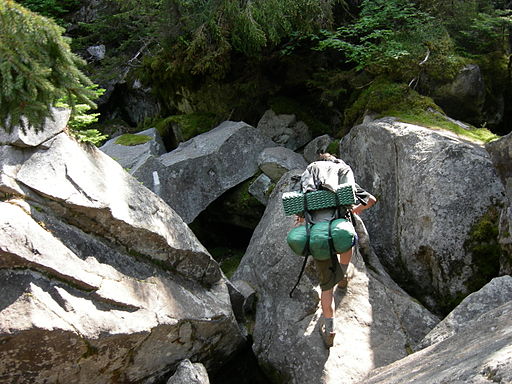
Thick wisps of mist floated past our faces as we clawed for footholds and handholds.
Old Speck
The guidebook informed us that near the top of Old Speck there was a pond called Old Speck Pond and a shelter next to it. We had been hoping for a view from the top of the mountain, as we did whenever we climbed a significant mountain, but the weather was not going to cooperate. The path was steep and slick, and as we gained elevation, we entered the clouds. Thick wisps of mist floated past our faces as we clawed for footholds and handholds. The climb was not as consistently steep as the way up Goose Eye Mountain, but it was a longer climb. The trees were taller and they loomed on either side of us, their trunks stained black by the rain and transformed by the mist into what looked like a set from a Transylvanian vampire movie. Near the top of Old Speck, the trail flattened out. There was a level section where the pond was situated. We were hiking through a thick stand of spruce and fir crowded on either side of us with branches arching overhead to form a mist filled tunnel. I thought Dave was a few minutes ahead of me when I suddenly came upon him. His pack was off, leaning against a tree, and he was bent over something in the middle of the trail. I walked up to see what he was doing.
"I got one," he said.
I looked over his shoulder to see him plucking the feathers off a freshly killed spruce grouse.
"This time when it flushed, I had just enough space to get a good swing with my stick."
"Wow," I said. I had stopped trying to whack the spruce grouses after about five or six attempts a couple days before.
"So are you going to cook it up for lunch?"
"Yep," Dave replied, "right up ahead at the shelter."
I helped Dave clean the bird for the next few minutes. I noticed that the bird was much smaller after the feathers had been plucked. What had seemed to be the size of a small chicken now looked not even half that size. We were only about 5 minutes from the shelter at Old Speck Pond. When we got there we found that it was occupied by a group of father and son campers. There were either two or three sets of fathers and sons with their stuff laid out all over the floor of the shelter. The mist was thick and it was difficult to distinguish a lot of details beyond what was right in front of us.
We approached the shelter and peered inside to find all the space taken. Dave was holding the grouse in one hand. One of the fathers turned out to be very friendly and talkative. He greeted us and then immediately noticed the plucked bird in Dave's hand.
"Hey! What you got there?" He asked.
Dave explained whacking the bird with his stick and his intention to cook it up for lunch.
The man responded with a lot of advice about how to cook up the grouse.
"There isn't much meat on them except for the breast," he informed us. "Just put it in a covered pan over your stove with a little boiling water and it will steam the meat. If you don't have a cover for your pan, just use some foil."
It sounded like good advice so that is what we did. We also added a Raman Noodles flavor packet to the water and ended up boiling the noodles along with the grouse. The man was right. The only significant meat on the grouse was the breast meat. Dave and I each ate half the bird. Mixed with the flavored noodles, it was very good.
When we were preparing the meal I went down to Speck Pond to get the water for the pan. The pond wasn't far from the shelter, but in the dense fog it seemed further. The shelter was hidden by the thick mist, and the sounds from the shelter were muted. As I knelt down at the gravelly edge of the pond I looked out across the water. The pond was ringed by the ghostly shapes of spruce and fir trees. Wisps of mist floated across the surface. For a moment I felt like I had been transported to an ancient land. I could imagine a woman's arm slowly rising up out of the water in the middle of the pond, holding a shining sword like the Lady of the Lake offering Excalibur to King Arthur. It didn't take me too long to fill the pan with water so my daydream was short-lived. Soon I was back at the shelter enjoying lunch and talking with the dads and their young sons.
Around three o'clock the mist started to break up so Dave and I decided to head on down to Grafton Notch. The shelter was too full for us to fit in comfortably, so we moved on down the trail. The way was steep going down the northern side of Old Speck Mountain. The skies gradually cleared as we descended, and part of the descent was down a steep open rock face.
Hiking down a steep slope, especially when wearing a backpack, is an exercise in restraint. Whereas hiking uphill is a brute force fight against the force of gravity to haul yourself and your pack upwards, descending is all about surrendering to the force of gravity little by little, every step finding the right mixture of letting go and resisting so you end up going downward, but not losing control and crashing into a tree or rock.
When we began our trip I tended to dread the uphill climbs. They made my muscles sore, my thighs burn, and they wore me out. As I continued and I got into shape, I actually started to dread the downhill sections especially the steep ones, more than the uphill sections. The step by step effort of resisting the constant tug of gravity while I picked my way down steep slopes put a lot of stress on my knees and ankles. Both Dave and I had long since gotten used to the lactic acid burn in our muscles, the increased heart rate, and the labored breathing involved in climbing with our packs, but we never could get used to the strain on our knees and ankles that resulted from descending a steep mountainside.
Wet conditions only made things worse, and a steep descent down a wet open rock face was the worst of all. Normally, even a steep descent down the mountain will have secure footing where a hiker can place their feet on flat spots almost like stair steps or at least soil where the thick lugs on Vibram soles can dig in and get a grip. On a steep rock face though, there is none of that. There is no soil and no flat spots, only an inclined plane. The grit of the rock usually provides enough traction for Vibram soles, but when wet, even that can be questionable. With these conditions in mind, Dave and I can be pictured gripping our hiking sticks tightly in both hands as we planted them carefully in front of us to lend extra support, our eyes darting back and forth, trying to judge where the roughest patches on the rock face were. Those were the spots where we wanted to step on the theory that rough patches could provide better traction than smooth ones.
Slowly we made our way down. The stress on our joints was expected, but we didn't anticipate the extra stress that the descent put on our boots. I was wearing a different set of boots than the ones I started the trip with. The soles of my previous pair had worn away at the toes and other parts where the soles attached to the boot. Meanwhile, Dave's boots, a pair of Herman work boots, had held up the entire way with no problems. The soles were thick and the stitching that held them to the leather had withstood all the stresses that 2000 miles on the trail could throw at them. It was the descent of Old Speck that finally did them in. My boots had worn away slowly over time, but Dave's blew out all at once. One moment he was wearing an intact boot and the next moment the leather completely tore away from the heel as he sidestepped down the rock incline. I heard him cry out and I looked over. He was stopped pointing down at his feet. I made my way over to him and he lifted his foot up to show me the Vibram sole hanging from the leather toe of his boot like a flip-flop.
Upon examination we could see that the force of Dave's foot pressing against the side of his boot had caused the leather to rip away from the stitching around the heel all the way past his instep.
Needless to say it was a slow process getting the rest the way down the mountain to the road at Grafton Notch. The turn of events, we realized, was going to set us back at least a day and a half, since we had to find a way to get to a town where Dave could buy new boots. At this point, so late in the trip, money was going to be an issue as well. We were running low. It was getting to the point where we didn't have too many travelers checks left and we knew that we had a few more rounds of food supplies to buy before we reached Katahdin.

Shoe Shopping
The road at Grafton Notch was deserted, and the information we had about nearby civilization was sketchy. Our guidebook told us there was a small place called Newry nearby, so we started hiking down the road in that direction. Before long we had a little bit of luck when someone stopped and gave us a lift to a crossroad where there was a general store. The crossroad, it turned out, was Newry. By that time it was late in the afternoon. We walked in, bought some snacks, and asked the proprietor where we could find a shoe store. He told us that Bethel, Maine was about 6 miles down the road, but by the time we got there the stores would be closed. He turned out to be a very nice man – he told us he was closing up soon, but we could set up our tent in the lawn behind his store. That we gratefully did.
The next day the man let us leave our packs at the store while we went into Bethel. We weren't able to get a ride, so we walked the 6 miles into town. Dave's boot sole slapped against the bottom of his foot at every step, actually sounding like a flip-flop as well as looking like one. Every once in a while he would have to shake his boot to deposit the bits of gravel that kept getting in under his foot.
When we reach Bethel, there were a few stores, but no sporting goods stores that sold hiking boots, and not even an Army Navy store or department store that sold work boots like the ones Dave had been wearing. Dave needed something with good tread and ankle support. We walked up and down the main street of the town looking for the best option. Finally Dave settled on a pair of high top basketball sneakers. At $15.95, at least the price was right. As it turned out, the sneakers served him well for the last 200 miles of the trip, and he probably ended up saving money over what new boots would have cost.
After Dave bought the sneakers, we had a run of luck. A guy that taught elementary school who was originally from St. Louis gave us a ride back to the general store in Newry where we picked up our packs. Since we were already off the trail we decided to get some supplies. The schoolteacher then said he could bring us to a grocery store in Andover where we could stock up. We offered our thanks to the general store proprietor, then loaded our packs into the schoolteacher's vehicle. Very shortly, he dropped us off at a store in Andover, then went on his way. Dave and I bought our supplies, uncertain as to how we would get back to the trail, but good fortune struck again when a friendly logger offered us a ride back to the trail after we had finished our shopping. It was afternoon when we returned to the trail. Our packs were fully loaded and Dave had a new look. His bright white footwear took some getting used to after months of seeing him in dark brown boots.
That night we camped near the trailhead. We were through the Mahoosucs. The steepest mountains we would face until Katahdin were behind us, but now we knew there were different obstacles in our path. Our guidebooks told us to expect miles of deep, thick mud through remote tracts of forest, swarms of mosquitoes and black flies, huge, unpredictable moose, and a river that we would have to ford with no bridge or boat to help us across. There would be many more obstacles to overcome before our journey would come to an end. All I knew, was that Dave and I were ready to tackle it all.


